A very different walk for me the other day, I’ve probably said it before but I’m amazed at how many footpaths I haven’t walked so close to home. Thinking myself as a bit a walker it can come as a bit of a shock sometimes although extremely enjoyable finding and exploring new ones. It was a special treat too as I was walking with my son Paul, although over six foot tall he takes some keeping up with! He led, with a bit of help from his mum in some places, but what a surprising walk it turned out to be. Again, this walk is a little complicated so you will definitely need your map. Paul usually just uses his phone to navigate but there were times when there was no signal so a paper copy is a must! Mum to rescue again!! I have to admit though he prepares at home and takes a screen shot just in case there is no signal. About seven miles in length but steep going in places and lots of stiles. Stay safe and enjoy!
We parked on Common Lane by the gallops on Middleham High Moor just above West Witton in Wensleydale by the footpath sign pointing north to West Witton and south to Melmerby. We went south to Melmerby cutting straight across the gallops to a ladder stile which you can just make out in the distance as you set off. Over the stile and through a couple of fields then into a large field heading for a gate with a wooden notice on it, about midway along the wall, but more or less just keeping south all the time. Through the gate to the next stile, onto the moor and wend your way through the heather towards the pine trees you can see in the distance. This will bring you down to a cattle grid and Melmerby.
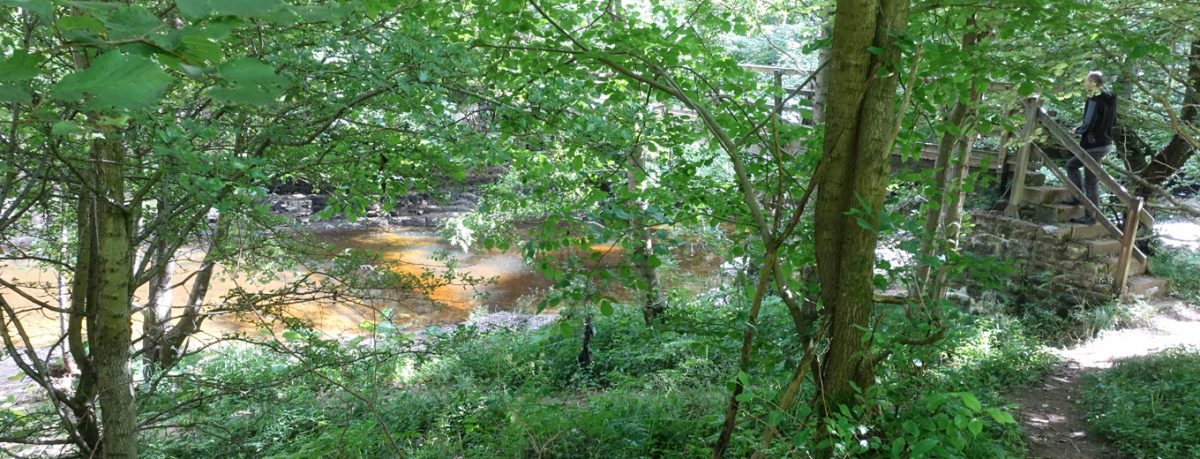
Over the cattle grid and walk the few yards to the next stile on your left, over here and walk along the fence to the next stile which takes you more or less into the farmyard. Through the gate on your left, down the field and through the gate at the bottom and onto the road. Turn right here and proceed to the next finger post on your left. Follow the track, skirting round the farm buildings at Middlefields Farm. At the next finger post we kept on the track as the field had wheat growing and we didn’t want to destroy anything here and the track continues to the road anyway. Right again to the next stile on the left, through here and down the fields to the wood. Into the wood, down the steps to the footbridge, St Simon’s Bridge over the River Cover, follow the path to the left. Pause to have a read of the little plaque by the ruins of St Simon’s Chapel, keeping going, up the steps which brings you out onto the road more or less at East Scrafton. Cross the road to walk up what looks a little like someone’s driveway but keep going to the first building and you will see a gate and stile here on the left. Through here and keep going straight across the field, down a little dip to the next stile gate, over the foot bridge, through the wood to eventually come out at Caldbergh. Perhaps time for a breather here!
Left down the road for a few yards then right to follow the finger post to Hanghow Pastures. If this road is blocked by farm animals as it was when we were there, just go back up the road a few yards and turn left on the track/road and pick up the path after you’ve skirted round the houses and the paddock. Straight across this field and through the metal gate in the far corner, over the dried up stream, it was when we were there, then turn right up the hill and make your way to a large oak tree on the left and a finger post. Keep going along this ridge over various wooden stiles, a small new planted area of trees, past a building and a stone stile. After here keep a very sharp look out for a wooden stile just after the start of the wood on the left. It took some finding as it was so overgrown but definitely there to be found, it does have a little post when you know what you’re looking for! Into the wood, a little to the right and you will see an avenue of pine trees to walk between, quite an adventure! Down and down to the next stile. Over into rough pasture and make your way down to the road through a gateway. Left here, walk a few yards along the road to the bridleway to Bird Ridding Wath, over the River Cover again on the metal footbridge, follow the path, keep going and come out onto the road and Tupgill Park (Forbidden Corner). Into Tupgill Park, go up the hill, past the lake, Fern Gill and out onto the gallops on Middleham Low Moor. If you'd like to stop for a bite to eat call in at The Forbidden Corner on your way past, just follow the signs as you walk past. Turn left along the track, in a westerly direction. As you look at the map you can see there is a bridleway running right through the middle of the gallops, make your way across to this, the grass is usually cut shorter, and follow to Common Lane and walk back on the road to your vehicle. Barely any traffic on here so pleasant enough and there are usually some riders and their beautiful steads to gaze upon.
Perhaps ready for a little more sustenance, venture to West Witton to the Wensleydale Heifer or the Fox and Hounds or a little further to Middleham or Leyburn, plenty of eating houses and pubs to choose from.
If you’d like to stay nearby we have stunning cottages in Wensleydale, have a look on our website for ideas and availability or do call me, Nadine, or my daughter Joanne on 01969 663559 for friendly help and advice.

Written By Nadine Bell


)